
 |
Menu |  |
|
|
||
 |
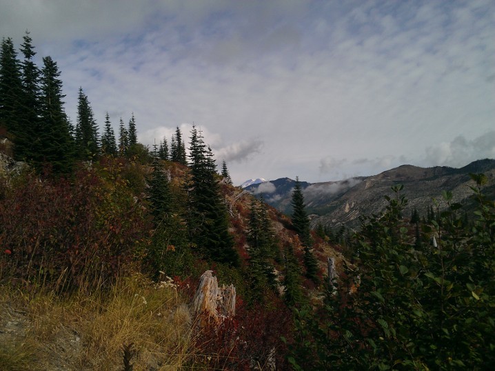
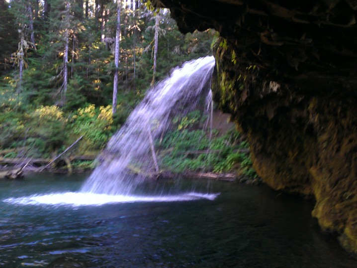
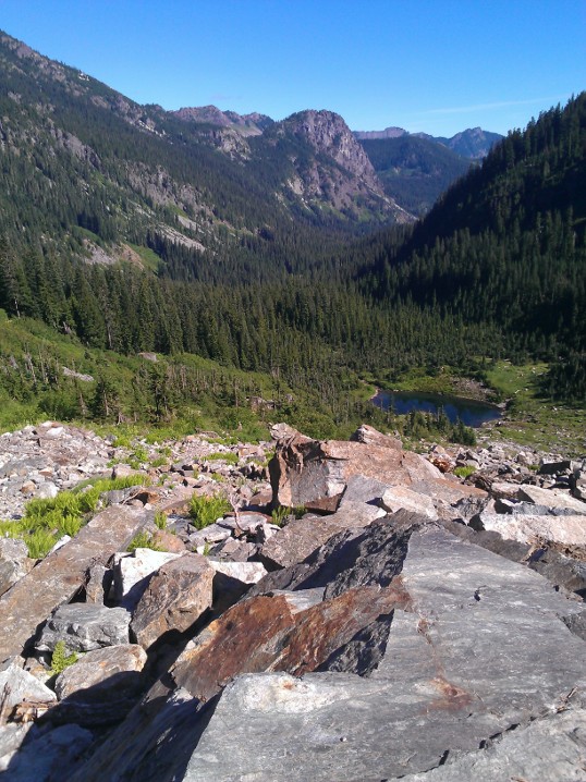
Welcome to UptonArt.netMount Saint Helens Tripposted October 4th, 2012 in Trip reports I set off last Saturday to visit volcano number two in the state, Mount Saint Helens, and specifically to hike at Norway Pass. The trailhead was about 3 hours from my apartment, and with the hike only being 4.5 miles it was clear that I needed to add something more to the trip to make it worth all the driving time, so I ended up making some other stops. Despite a mostly sunny forecast for the park area, it was dreary for most of the trip and even rainy at times. Once I got farther south, entered the Gifford-Pinchot National Forest, and started to increase in elevation, the clouds eventually mostly cleared. There were several great opportunities for atmospheric shots, or there would have been if there were any places to pull off the road; I would also have had some good chances for shots of clouds nestled in the valleys if the road had not been tree-lined at that point. For my Rattlesnake Ledge hike, I had to complain about hiker etiquette, and for this trip I guess I have to complain about park driver etiquette. I get it, maybe you’re just out for a nice drive through the forest, or aren’t sure where you’re going, but that doesn’t make it okay to drive 10 or 15 under the limit and repeatedly fail to use pullouts to faster people go by. The route to the trailhead is a series of national forest roads, and they’re only moderately well-maintained. The last road out to the trail in fact was partly grown over, in the sense that bushes are growing pretty much unchecked along the road and sprawling out into it. On the other hand, most of the area around the volcano is pretty desolate after the blast in 1980, so maybe they figure it’s better to let things grow back anyway. The trail itself has a warning as you enter that you should bring plenty of water because it’s a dry trail. I guess if you wanted to, you could add an extra mile or so and stroll down to Spirit Lake, but other than that the only water I actually saw along the trail was a fairly stagnant pool in a stream. (I say that I saw because I definitely heard a waterfall somewhere, but I have no idea where.) The bottom of the trail is pretty sandy and makes walking a bit frustrating, kind of like walking along the beach, but it eventually turns into more of just a well-beaten dusty path. The trail forks in several places and unfortunately the destination of Norway Pass is not actually on any of the signs, but I had looked in advance (and some other hikers were able to confirm to me) that I just wanted to stay on Boundary Trail #1. At some points, you could see Mount Rainier peaking out from behind other mountains, although eventually it collected some clouds and went into hiding.
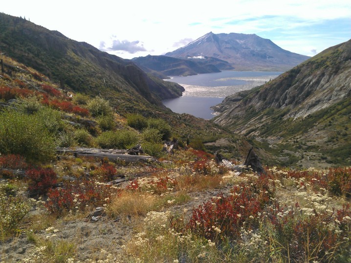
The arrival at the pass is somewhat underwhelming, because it’s just a fork where you can continue along the Boundary Trail #1 to some other trails, or theoretically fork to another trail that was currently closed due to washouts. But if you continue another hundred feet or so, you get a nice view of Spirit Lake and Mount Saint Helens.
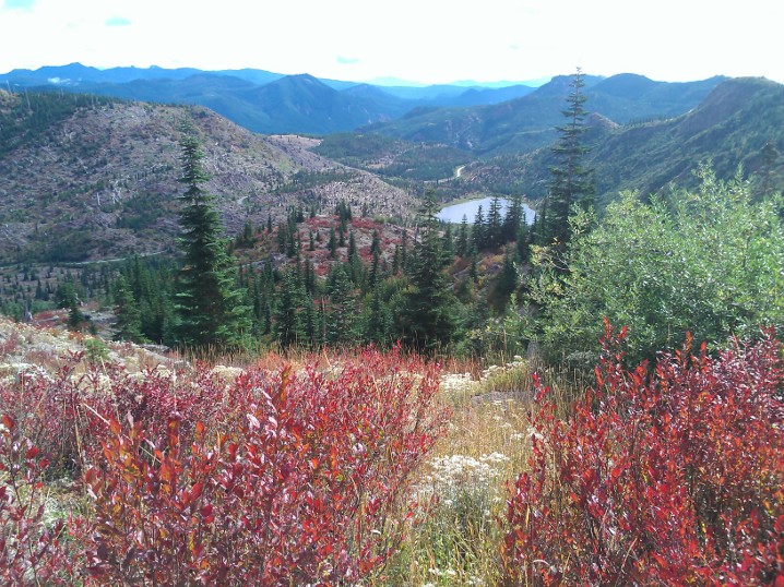
On the way back, some other hikers showed me the huckleberry bushes, which I knew were around and ripe but I had previously not known how to identify, so I got to snack on berries on the way back down. As you come back down the trail, you get a nice view of some of the smaller mountains in the area, as well as Meta Lake.
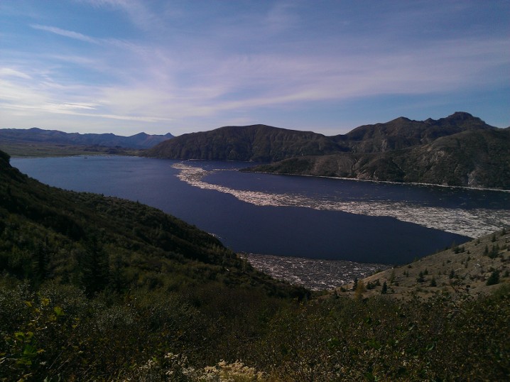
After finishing up there, I decided to drive out to Windy Ridge, because I was under the (incorrect) impression that it had a visitor center. What it does have is a couple hundred feet of stairs up to an observation deck on the ridge, which gives you another nice view of Spirit Lake and the volcano.
The actual visitor center was on my way back at a place called Cascade Peaks, where I found out the visitor center was closed for the season. It’s okay, park service, it’s not like I wanted to buy a post card or anything. As I headed out of the park and back into national forest land, I stopped at Iron Creek Falls. I had read about it before leaving and the webpage mentioned that the lighting was funky in the afternoon so it was better to stop in the morning, and so that’s what I had planned to do. Unfortunately, the signage was a bit confusing. Normally, I’m used to seeing a notice of a trail head or attraction at least a little in advance, so when I saw the sign that said “Iron Creek Falls 500 ft” with a left arrow, I figured it meant the parking lot was in 500 feet. There was no such thing, so I just continued on to Norway Pass. It turns out that sign was at the end of the parking lot (which I hadn’t noticed because I was just looking for a sign), and the sign actually was pointing to the trail and saying the waterfall was 500 ft down the trail.
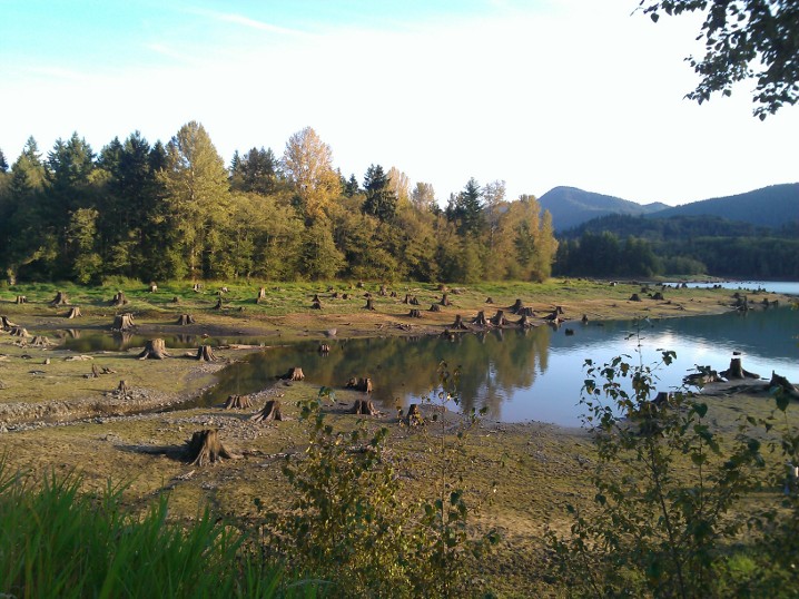
On the way back, I stopped at a park I had driven by several times that is unlabeled on Google Maps or Bing Maps but I believe is called Sun Point Park. What had always drawn me to it, despite the fact I had never stopped before, is the collection of giant tree stumps along the lake shore. I chatted with another photographer there and he mentioned that they were remnants of trees that had probably been cut down 80 or 90 years ago and that you get different scenes depending on the water level of the lake. (The lake must get up much higher than what it was that day, because the whole area was very wet, squishy mud.)
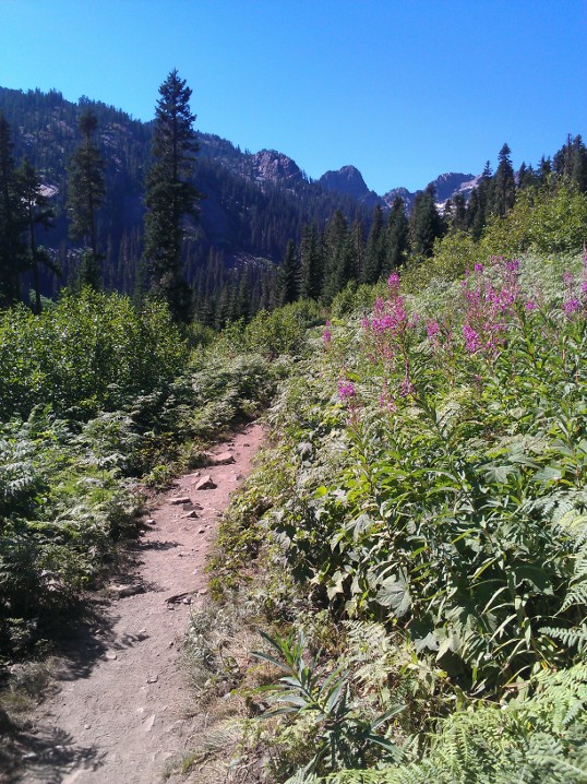
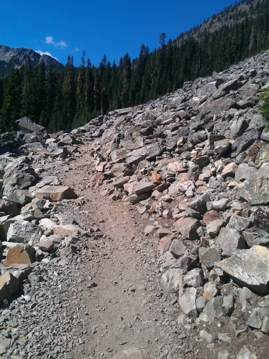
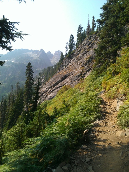
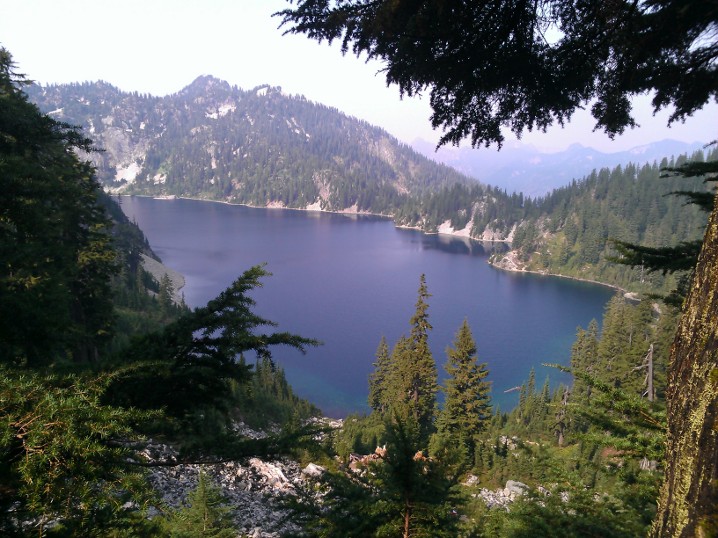
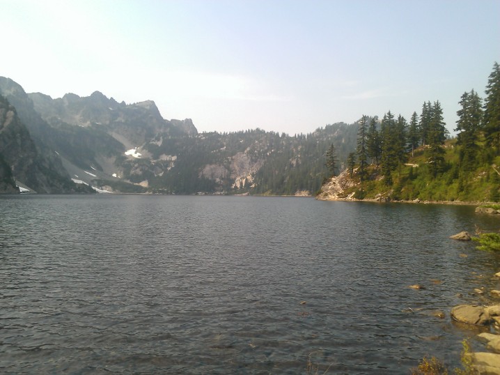
I had intended to come straight home after that, but I ended up stopping at a little roadside pullout north of Eatonville that i had again driven past several times before — it said something about it being a historical marker as well as a scenic view. I didn’t see what the marker was, but it has an unobstructed view of Rainier and so I got to watch the sunset light up the mountain. No Comments on Mount Saint Helens TripSource Lake and Snow Lakeposted September 24th, 2012 in Trip reports This is actually a combined trip report, one from today and one from three weeks ago. It’s not as completely random as it sounds, though, because both Source Lake and Snow Lake are a part of the Alpine Lakes Wilderness. My snowboard teacher had been recommending them both to me, so I finally decided to check them out. Conveniently, there’s a huge amount of parking at the trailhead, since it shares a parking lot with the Alpental ski area. First, three weeks ago, I visited Source Lake, so named as the source of the South Fork of the Snoqualmie River. (The river must have a great many tributaries, given the amount of water in the lake compared to the amount of water other places I’ve been along the South Fork.) The hike is fairly easy, with maybe one or two steep parts but mostly a gentle climb. When I hiked there, about the only wildflowers remaining were some fireweed along the trail closer to the beginning. Most of the hike is exposed, either along the side of the mountain or along some boulder slides.
I wanted to go play on the one remaining snow pile near the lake, but I couldn’t find a good way to get to it. It was a reasonably easy hike up to there, so I thought about continuing on to Snow Lake, but decided I should stick to the hiking plan people knew about instead of continuing on. Instead, I made it out today, since it was a much nicer weather day than yesterday. The trail follows the same trail as Source Lake for about the first two miles (okay, technically, it’s the other way around; it’s the Snow Lake trail, and the trail to Source Lake spurs off of it), and then it starts to switch back and forth up about another 4-500 feet over another mile. You hit a ridge and then descend 350 feet, give or take, down to the lake shore. I finished the stroll down to the lake behind a group of 4 other people, one of whom decided “snow” meant she should sing Christmas carols. After one of the other girls in the party said, “No carols until November,” she switched to random pop songs. Someone then wondered aloud how many people had taken to the wilderness to get away from “people like her;” the guy hiking (separately) in front of them raised his hand. I bumped into one of my coworkers on the way up the trail, and he remarked that the lake was a zoo; even given the number of people I passed exiting as I was going in, it was still pretty popular mid afternoon. On the other hand, it’s a big area, so it didn’t feel that crowded or loud — at least, until two groups’ dogs decided they couldn’t swim in the same part of the lake and instead should bark at each other. I continued along the trail for a while to get to some rock outcroppings, but then turned around before I tried to find my way all the way to the opposite end of the lake.
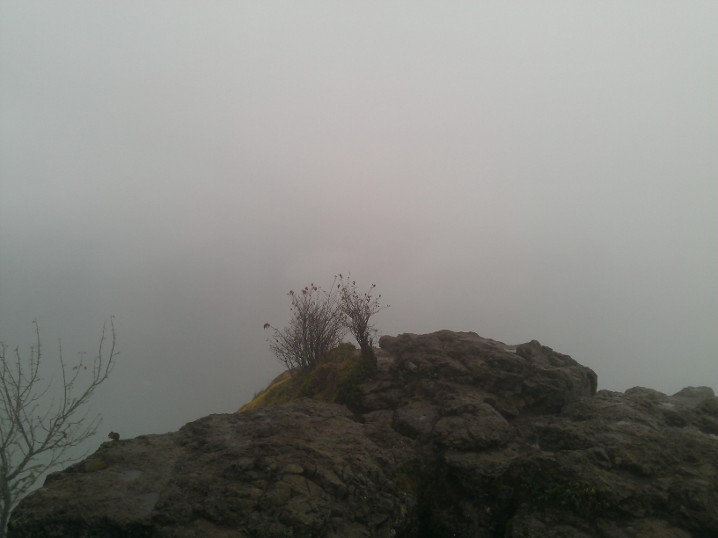
Rattlesnake Ledge, reduxposted September 23rd, 2012 in Trip reports I decided yesterday that I should go hiking somewhere, partly because I’m rapidly running out of “good” weekends to hike and partly to start to scope out the foliage in the area. I didn’t make this decision until fairly late in the afternoon though, which limited my options to somewhere fairly close by and not too long. I decided I would give Rattlesnake Ledge another go — I’d hiked it back around early March and got rained/sleeted/snowed on, so it couldn’t be any worse. It wasn’t much better, either, except for being about 15 or 20 degrees warmer. I woke to rain in Redmond, but by the afternoon it had started to clear up enough that I could at least see some blue in the sky. As it turns out, the clouds had not blown away as much over around North Bend. It misted and sprinkled on me on the way up, along with rain falling off of the trees, but nothing heavy. When I got to the top, it was still completely wrapped in fog:
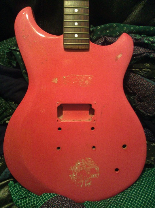
…although the fog did lift enough to see back down to the lake before I left. There were a couple squirrels and one chipmunk running around begging food from the other hikers; even on a lousy weather day, it was a fairly popular hike. The worst of the hike was a group of people who haven’t been lectured enough on trail etiquette, which I guess is a downside of hiking a popular, accessible, “relatively” easy trail. It’s a fairly narrow trail for most of the hike, which means there are not many good places to pass; I got stuck behind a group of three people walking in a V formation to take up the whole trail. They looked back at me several times and showed no interest in forming into a single line or pulling over to the side to let me by. Oh well, I eventually found a way past them, sped on to the top, and passed them about a quarter mile from the top as I was heading back down. No Comments on Rattlesnake Ledge, reduxNaches Peak Loop/Tipsoo Lakeposted September 6th, 2012 in Trip reports I’d been planning on waiting until I had some pictures ready to go up with this one, since it was very much a photography hike, but apparently my hard drive is like purgatory for pictures. The last weekend of August I made my way up to Tipsoo Lake and the Naches Peak loop trail, which is “sort of” in Mount Rainier National Park. I think the trailhead technically is in the park, but not in a section where they actually enforce an entry fee. Parts of the hike then cross the Snoqualmie National Forest and maybe one other National Forest area. The trail goes along part of the Pacific Crest Trail, so now I can say I’ve “started” two of the three trails on the Triple Crown of Hiking, and two of the four long trails that I think I would like to do. (I’ve hiked bits and pieces of the Appalachian Trail, of course, in VA; the other two are the Continental Divide Trail, which I think I have missed both times I’ve been in its general vicinity, and the John Muir Trail in the Sierra Nevada range.) I actually could’ve gotten in more of the PCT while I was out that day, but it would’ve added three miles to the hike. On its own, that wouldn’t have been bad, but it would have started off going downhill toward Dewey Lake, and I had no idea how steep it was. As a result, I wasn’t sure how long it would take, and I thought I might start to run short on daylight if it took too long. In short: despite the huge number of people and accompanying nightmarish parking situation, this is definitely a hike worth doing. After all, there must be a reason everyone else was there, right? It’s a fairly easy stroll, as the WTA guide notes, without any long steep sections. The first half heads east and then south around Naches Peak at ~6400 ft, with a couple short gains but mostly rolling up and downhill along the rocks. Then you turn west to return to the parking lot and you basically spend your time walking through meadows full of wildflowers and staring at Mount Rainier. I think I heard a ranger say there would be flowers for another week or two and then it would quickly transition to fall colors, so I might have to head up again soon. No Comments on Naches Peak Loop/Tipsoo LakeGuitar Project – Part 1posted September 2nd, 2012 in Guitar Back in February, somebody at work was giving away a few project guitars that they had gotten at some point and had since given up on ever actually working on. I managed to win the race to claim one of them, although I don’t know how much of a race was involved because the description of “hot pink” may have put some people off. It turned out to be an Ibanez Studio, which the Wikimedia Commons suggests was built between 1978 and 1982. It came with a pair of humbuckers, but it seems that one of the previous owners decided against the neck pickup and filled in the cavity with something. I guess I’ll have to decide whether I want to get it routed back out or just leave it as a one-pickup guitar. But first, there’s the matter of getting it to a state that I can work on it. First, it was originally covered in stickers. I took off the strings, and the tailpiece and, at the suggestion of a guy from Home Depot, used Mötsenböcker’s Lift Off to remove the stickers. It kind of worked, although I’m not sure how much difference the sticker removal stuff did versus just soaking them in water — I still had to scrape/chisel the stickers off. Once that was done, I had two more things to remove. First, the bridge was very much stuck in place, courtesy a pair of screws holding it in place that basically no longer had a slot for a screwdriver. What was there got chewed up pretty quickly by trying to turn them; it seemed to be pretty soft metal. I actually don’t remember at this point how I got them out, but it may have involved hammering a flathead screwdriver into them just enough to get the screwdriver to grab. You know, take advantage of the fact the metal was soft and getting eaten up by the screwdriver anyway. Second, I had to remove all of the electronics. This was basically where the project stalled because I am inexplicably terrified of using a soldering iron. After a few months, I asked around either for suggestions or at the very least a pep talk that I could successfully desolder the electronics without burning myself/burning the apartment down. That was when some helpful people on the luthiery subreddit pointed out that for the most part I was going to want to replace the electronics anyway (even if I didn’t replace the pickup, which I probably will), so I could at least postpone the hassle of soldering by just clipping the old wires. Sounds like a winner to me! The pickup end of the wire coming from the pickup is stuck somewhere in the case, so I had to be careful to snip it tight against the original solder, leaving as much of the original wire as possible. The rest of it was less important but I still tried to cut everything tight. There’s still one random wire that I have no idea where it’s connected on the other end; I’m guessing it’s a spare wire from the electronics that are no longer there. But now I have a hot pink guitar body sans stickers and electronics that I can spend the next x amount of time sanding down. (Because of course I’m going to sand it all down by hand, while trying not to get pink paint dust all over everything in my apartment in the process.) No Comments on Guitar Project – Part 1 |
 |
Recent |  |